Virunga Mountains: Location, Volcanoes, Wildlife & Gorilla Trekking
The Virunga Mountains, also known as the Virunga Massif, are a stunning chain of volcanoes located in East-Central Africa, forming a dramatic natural barrier where the borders of Rwanda, Uganda, and the Democratic Republic of Congo (DRC) converge.
This volcanic range is renowned worldwide for its breathtaking landscapes, active volcanoes, and as a critical habitat for endangered mountain gorillas. Spanning approximately 120 kilometers, the Virungas are part of the larger Albertine Rift, a biodiversity hotspot that supports an incredible array of flora and fauna.
The mountains’ importance cannot be overstated—they are home to roughly half of the world’s remaining mountain gorillas, making them a focal point for conservation efforts and eco-tourism.
For travelers, students, researchers, and safari planners, the Virunga Mountains offer a unique blend of adventure and education. Whether you’re drawn to the thrill of gorilla trekking, the challenge of hiking active volcanoes, or the opportunity to witness conservation in action, this region provides unforgettable experiences.
In this complete guide, we’ll explore the geography, volcanoes, wildlife, national parks, activities, best times to visit, travel requirements, and conservation history of the Virunga Mountains, helping you plan your journey while highlighting why this area deserves protection.
Location & Geography of the Virunga Mountains
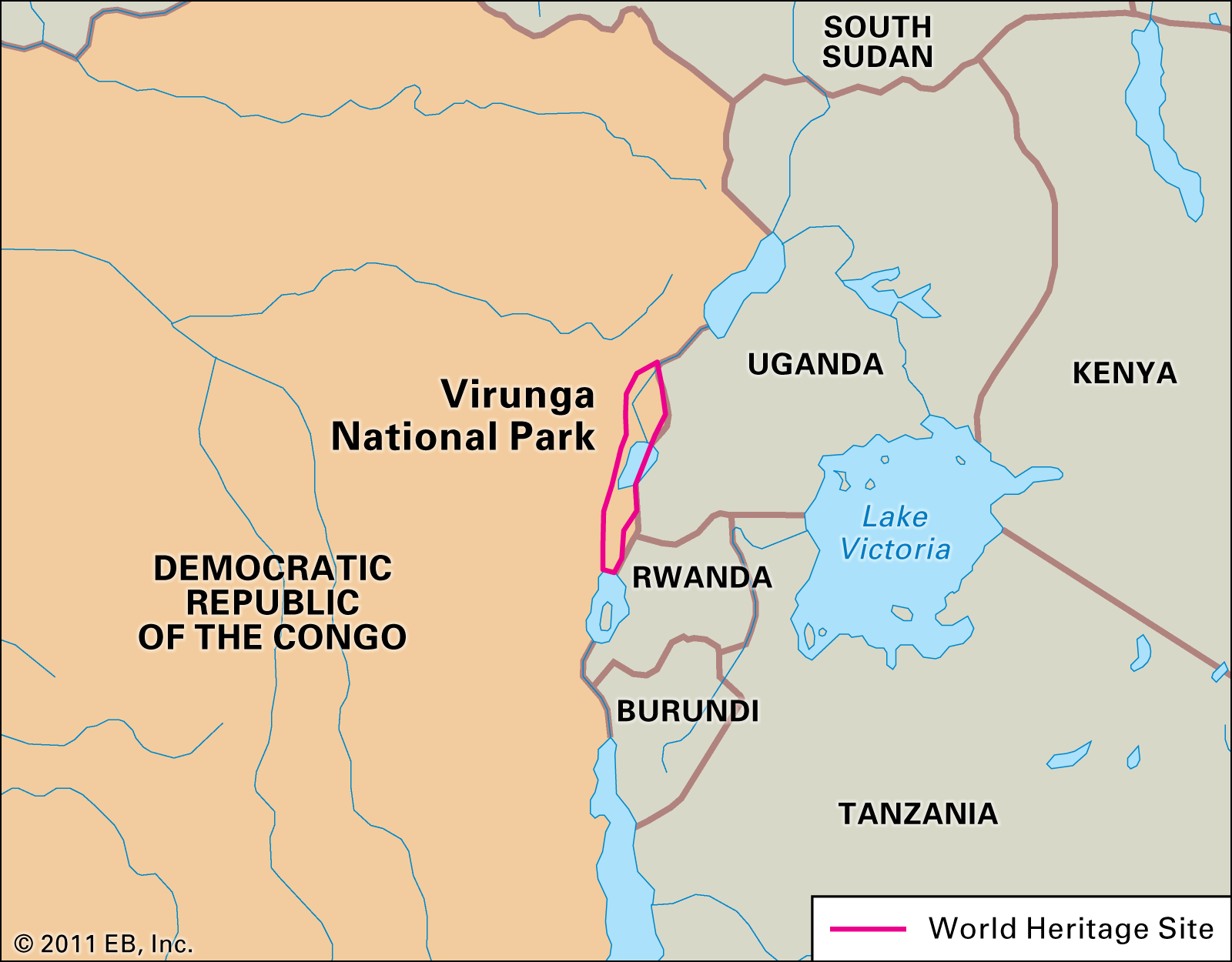
Nestled in the heart of East-Central Africa, the Virunga Mountains straddle the borders of three countries: Rwanda, Uganda, and the Democratic Republic of Congo (DRC). This transboundary location adds to the region’s complexity and allure, as each nation contributes to its management and offers distinct access points.
The mountains form the southern part of the Virunga Volcanoes chain, which is itself a segment of the Albertine Rift—a western branch of the East African Rift Valley system.
The Albertine Rift is one of Africa’s most biodiverse areas, characterized by dramatic tectonic activity that has shaped the landscape over millions of years.
Geographically, the Virungas rise abruptly from the surrounding plains, with elevations ranging from about 2,000 meters to over 4,500 meters at their highest points.
The terrain is rugged, featuring steep slopes, dense montane forests, bamboo zones, and alpine meadows at higher altitudes. Volcanic activity has enriched the soil, supporting lush vegetation that thrives in the region’s equatorial climate. However, this fertility also attracts human settlement, leading to ongoing conservation challenges.
The mountains’ position near the equator means they experience a tropical highland climate, with temperatures moderated by altitude.
Daytime highs in the lower elevations can reach 25°C (77°F), while summits may drop below freezing at night. Rainfall is abundant, averaging 1,500–2,000 mm annually, feeding rivers that flow into Lake Edward and Lake Kivu. This water system is vital for local communities and wildlife, but it also poses risks like landslides during heavy rains.
For those interested in the Virunga Mountains location, key entry points include Goma in the DRC for the southern volcanoes, Kisoro in Uganda for the eastern parks, and Musanze (formerly Ruhengeri) in Rwanda as a hub for northern access.
The massif’s cross-border nature requires careful planning for visas and permits, but it allows for multi-country itineraries that showcase the region’s unity in diversity.
Below is a map of the Virunga Mountains;
This geographical setup not only influences tourism but also underscores the need for collaborative conservation across nations.
Volcanoes of the Virunga Mountains
The Virunga Mountains are synonymous with their iconic volcanoes, a chain of eight major peaks that dominate the skyline and drive much of the region’s geological interest.
These volcanoes are the result of tectonic forces along the Albertine Rift, where the African Plate is splitting apart, allowing magma to rise and form cones over time.
While most are dormant or extinct, two remain active, adding an element of excitement—and occasional hazard—to visits.
Here’s a detailed list of the Virunga volcanoes, including their locations, elevations, and notable features:
- Mount Karisimbi: The highest in the range at 4,507 meters (14,790 feet), straddling Rwanda and the DRC. This stratovolcano is dormant, with its summit often capped in snow during dry seasons. Hiking Karisimbi takes 2 days and offers panoramic views, but it’s challenging due to steep terrain and high altitude.
- Mount Mikeno: Reaching 4,437 meters (14,557 feet) in the DRC. Known for its eroded slopes and as a habitat for mountain gorillas, Mikeno is deeply forested and less frequently climbed.
- Mount Muhabura: At 4,127 meters (13,540 feet), on the Rwanda-Uganda border. This conical peak, meaning “The Guide” in local language, provides stunning vistas and is a popular day hike from Uganda.
- Mount Bisoke (Visoke): 3,711 meters (12,180 feet), Rwanda-DRC border. Features a crater lake at the summit, ideal for moderate hikes. It’s a biodiversity hotspot with unique flora.
- Mount Sabyinyo: 3,674 meters (12,050 feet), where Rwanda, Uganda, and DRC meet. The “Old Man’s Teeth” due to its jagged ridges, this is one of the oldest volcanoes and a tri-border summit point.
- Mount Gahinga: 3,474 meters (11,400 feet), Rwanda-Uganda. Smaller and forested, it’s known for golden monkey habitats and easier ascents.
- Mount Nyiragongo: 3,470 meters (11,385 feet) in the DRC, famous for its persistent lava lake—one of the world’s largest. Active, with eruptions in 2002, 2021, and ongoing activity. Overnight hikes to the crater rim are thrilling but require caution.
- Mount Nyamuragira: 3,058 meters (10,033 feet) in the DRC, Africa’s most active volcano. Frequent eruptions shape the landscape, but it’s less visited due to remoteness.
The Virunga volcanoes attract geologists, adventurers, and photographers. Mount Nyiragongo’s lava lake, a glowing red cauldron, is a highlight for those seeking natural wonders.
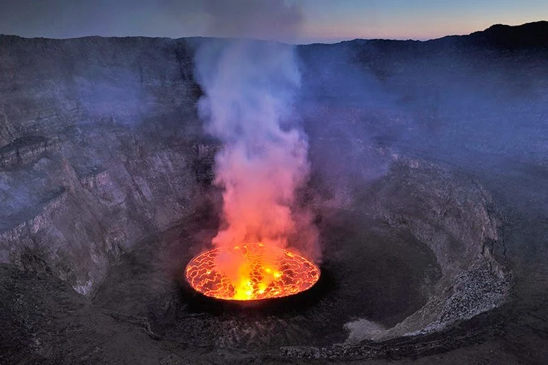
Mount Nyiragongo
However, volcanic risks like gas emissions and eruptions necessitate guided tours and monitoring by local authorities.
Wildlife & Biodiversity in the Virunga Mountains
The Virunga Mountains’ biodiversity is unparalleled, earning the region UNESCO World Heritage status. Dense forests, bamboo groves, and alpine zones support over 3,000 species, including many endemics to the Albertine Rift.
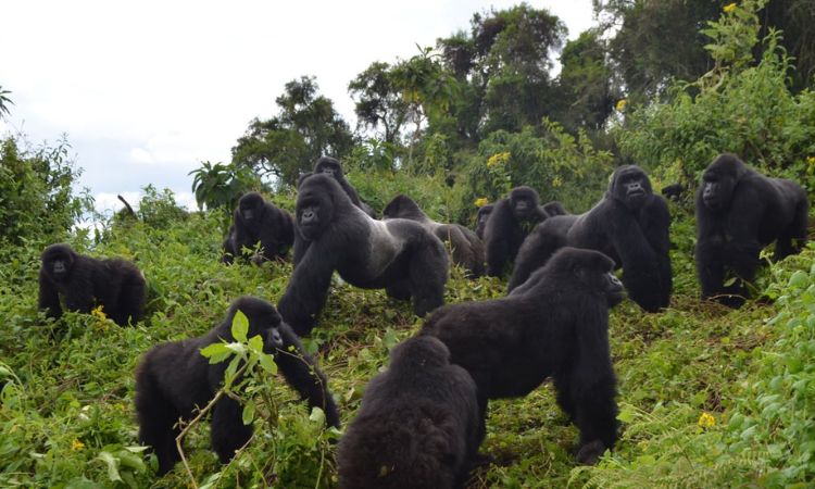
The star attraction is the mountain gorilla (Gorilla beringei beringei), with around 600 individuals in the Virungas—half the global population. These gentle giants live in family groups, foraging in the undergrowth and providing mesmerizing encounters for visitors.
Other primates include golden monkeys, known for their vibrant fur and playful troops in bamboo forests. Chimpanzees inhabit lower elevations in the DRC sector, while colobus monkeys and baboons are commonly spotted.
Larger mammals like forest elephants, buffaloes, and okapis roam the parks, though they’re elusive due to dense vegetation. The region is a birdwatcher’s paradise, with over 700 species, including Albertine Rift endemics like the Rwenzori turaco and handsome francolin.
Plant life is equally diverse, from giant lobelias in alpine zones to orchids and ferns in montane forests. This ecosystem supports vital services like water catchment and carbon sequestration. However, threats like habitat fragmentation endanger this richness, making conservation crucial.
Observing mountain gorillas in their natural habitat is a profound experience, highlighting the Virungas’ role as a gorilla sanctuary.
Biodiversity here isn’t just about species—it’s a web of life sustaining local communities and global heritage.
National Parks in the Virunga Mountains
Three national parks protect the Virunga Mountains, each offering unique access to the massif’s wonders. These protected areas collaborate on conservation while catering to different visitor preferences.
- Virunga National Park (DRC): Africa’s oldest national park, established in 1925, covering 7,800 square kilometers. It encompasses the southern Virungas, including Nyiragongo and Nyamuragira. Known for gorilla trekking, volcano hikes, and diverse habitats from savannas to glaciers. Despite past conflicts, it’s rebounding with eco-tourism initiatives.
- Volcanoes National Park (Rwanda): Spanning 160 square kilometers in northern Rwanda, this park is synonymous with gorilla trekking. Home to 12 habituated gorilla families, it also features hikes to Karisimbi and Bisoke. Infrastructure is excellent, with luxury lodges nearby.
- Mgahinga Gorilla National Park (Uganda): The smallest at 34 square kilometers, bordering the other two parks. Focuses on gorilla and golden monkey tracking, plus volcano climbs like Muhabura and Gahinga. It’s ideal for combining with Bwindi Impenetrable National Park for extended safaris.
These parks form a transboundary conservation area, allowing wildlife to move freely. Entry fees support ranger patrols and community projects, ensuring tourism benefits locals.
Things to Do in the Virunga Mountains
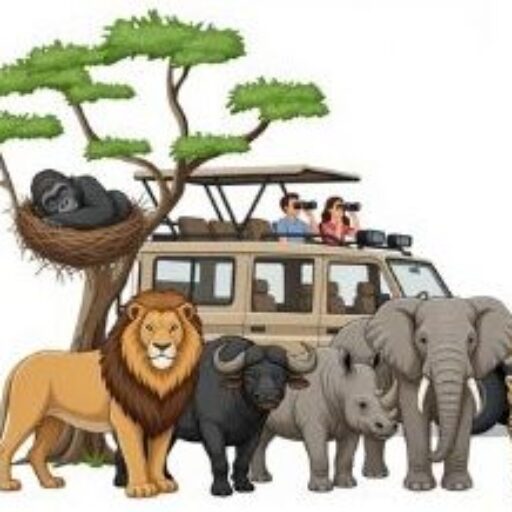
The Virunga Mountains offer a plethora of activities for adventure seekers, nature lovers, and cultural enthusiasts. Topping the list is gorilla trekking, where small groups track habituated families for a one-hour observation. This intimate encounter, often involving hikes through misty forests, is life-changing and requires physical fitness.
Golden monkey tracking provides a lighter alternative, following troops through bamboo zones. Volcano hiking ranges from day trips to Bisoke’s crater lake to overnight ascents of Nyiragongo for lava views.
Birdwatching yields sightings of rare species, while cultural encounters with Batwa pygmy communities offer insights into indigenous life.
Photography safaris capture the dramatic landscapes, and multi-day safaris combine trekking with wildlife viewing. Safety is prioritized with armed rangers, but check advisories due to regional instability.
Gorilla trekking in Virunga National Park exemplifies the thrill of these activities.
![]()
Whether hiking or relaxing in lodges, the Virungas deliver immersive experiences.
Best Time to Visit the Virunga Mountains
Timing your visit to the Virunga Mountains depends on weather, activities, and crowd levels. The region has two dry seasons: June to September and December to February, ideal for trekking and hiking.
During these periods, trails are drier, reducing mud and improving accessibility. Temperatures range from 15–25°C (59–77°F) during the day, with cooler nights at higher altitudes. June to August sees peak tourism, with clear skies perfect for volcano views and gorilla sightings.
The wet seasons—March to May (long rains) and October to November (short rains)—bring heavier precipitation, averaging 200–300 mm monthly, making paths slippery and hikes more strenuous. However, gorillas descend to lower elevations, potentially shortening treks, and landscapes burst with greenery.
Birding is excellent during rains, with migratory species arriving. Low-season discounts apply, but expect occasional closures due to weather.
Year-round, high-altitude areas can be cold and foggy, so pack layers. For gorilla trekking, book permits months in advance for dry seasons. Ultimately, dry months offer the most reliable Virunga Mountains weather for comfortable exploration.
Permits, Fees & Travel Requirements
Visiting the Virunga Mountains requires permits and fees that fund conservation. Gorilla trekking permits vary: $1,500 in Rwanda (including park entry), $800 in Uganda, and $450 in the DRC (discounted to $250 in low season). Book 3–6 months ahead, especially for peak times.
Park entry fees: Volcanoes NP (Rwanda) included in permits; Mgahinga (Uganda) $40; Virunga NP (DRC) $35–$100 depending on activities. Volcano hikes like Nyiragongo cost $300–$400, including overnight stays.
Travel requirements include visas: Rwanda and Uganda offer e-visas ($50–$100); DRC requires embassy applications and letters of invitation.
Border crossings need planning; use reputable operators. Health: Yellow fever vaccination mandatory; malaria prophylaxis advised. COVID protocols may apply.
Budget for guides ($50–$100/day) and porters ($20). These fees support communities and protection.
Conservation & History of the Virunga Mountains
The Virunga Mountains’ conservation history is marked by triumphs and tragedies. Established as Albert National Park in 1925 (now Virunga NP), it was Africa’s first, aimed at protecting gorillas from poaching.
In the 1960s, Dian Fossey arrived, inspired by George Schaller, and founded Karisoke Research Center in 1967. Her work documented gorilla behavior and fought poachers aggressively, raising global awareness through “Gorillas in the Mist.”
Fossey’s murder in 1985 shocked the world, but her legacy endures via the Dian Fossey Gorilla Fund. Gorilla numbers plummeted to 250 in the 1980s due to poaching, habitat loss, and civil wars. Conservation efforts, including anti-poaching patrols and community tourism, led to recovery—gorillas reclassified from critically endangered to endangered in 2018.
Current threats include poaching, deforestation for agriculture, disease transmission from humans, and climate change impacting habitats. Over 175 rangers have died protecting Virunga since 1996. Initiatives like revenue-sharing and education empower locals, ensuring sustainable tourism.
The Virungas’ story is one of resilience, where human dedication safeguards this irreplaceable ecosystem.
FAQs about Virunga Mountains
Where are the Virunga Mountains located?
The Virunga Mountains are in East-Central Africa, spanning Rwanda, Uganda, and the DRC, within the Albertine Rift.
Which countries share the Virunga Mountains?
Rwanda, Uganda, and the Democratic Republic of Congo share the range, with parks in each.
Are the Virunga Mountains safe to visit?
Safety varies; Rwanda and Uganda are stable, but DRC requires caution due to volatility. Use guided tours and check advisories.
Can you see gorillas in the Virunga Mountains?
Yes, gorilla trekking is available in all three parks, with habituated families for observation.
What is the highest mountain in the Virunga range?
Mount Karisimbi, at 4,507 meters.